ArangoDB v3.8 reached End of Life (EOL) and is no longer supported.
This documentation is outdated. Please see the most recent version at docs.arangodb.com
Geospatial Search with ArangoSearch
ArangoSearch supports geospatial queries like finding coordinates and GeoJSON shapes within a radius or area
ArangoSearch can accelerate various types of geospatial queries for data that is indexed by a View. The regular geospatial index can do most of this too, but ArangoSearch allows you to combine geospatial requests with other kinds of searches, like full-text search.
Creating geospatial Analyzers
Geospatial data that can be indexed:
- GeoJSON features such as Points and Polygons
(with coordinates in
[longitude, latitude]order) - Raw coordinates (
[latitude, longitude]arrays or two separate attributes)
The data needs to be pre-processed with a geojson Analyzer in case of GeoJSON
and with a geopoint Analyzer in case of raw coordinates. These Analyzers need
to be created manually.
Custom Analyzers:
Create a geojson Analyzer in arangosh to pre-process arbitrary GeoJSON shapes.
The default properties are usually what you want, therefore an empty object
is passed:
//db._useDatabase("your_database"); // Analyzer will be created in current database
var analyzers = require("@arangodb/analyzers");
analyzers.save("geojson", "geojson", {}, ["frequency", "norm", "position"]);
See geojson Analyzer for details.
Create a geopoint Analyzer in arangosh to pre-process raw coordinate arrays
using the default properties, hence passing an empty object:
//db._useDatabase("your_database"); // Analyzer will be created in current database
var analyzers = require("@arangodb/analyzers");
analyzers.save("geo_pair", "geopoint", {}, ["frequency", "norm", "position"]);
Create a geopoint Analyzer in arangosh to pre-process raw coordinates with
latitude and longitude stored in two different attributes. These attributes
cannot be at the top-level of the document, but must be nested in an object,
e.g. { location: { lat: 40.78, lon: -73.97 } }. The path relative to the
parent attribute (here: location) needs to be described in the Analyzer
properties for each of the coordinate attributes:
//db._useDatabase("your_database"); // Analyzer will be created in current database
var analyzers = require("@arangodb/analyzers");
analyzers.save("geo_latlng", "geopoint", { latitude: ["lat"], longitude: ["lng"] }, ["frequency", "norm", "position"]);
Using the example dataset
Load the dataset into an ArangoDB instance and create a View restaurantsViews
as described below:
Dataset: Demo Geo S2 dataset
View definition:
{
  "links": {
    "restaurants": {
      "fields": {
        "location": {
          "analyzers": [
            "geojson"
          ]
        }
      }
    }
  },
  "neighborhoods": {
    "fields": {
      "name": {
        "analyzers": [
          "identity"
        ]
      },
      "geometry": {
        "analyzers": [
          "geojson"
        ]
      }
    }
  }
}
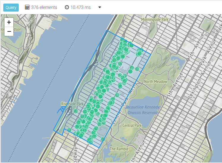
Search for points within a radius
Using the Museum of Modern Arts as reference location, find restaurants within a 100 meter radius. Return the matches sorted by distance and include how far away they are from the reference point in the result:
LET moma = GEO_POINT(-73.983, 40.764)
FOR doc IN restaurantsView
  SEARCH ANALYZER(GEO_DISTANCE(doc.location, moma) < 100, "geojson")
  LET distance = GEO_DISTANCE(doc.location, moma)
  SORT distance
  RETURN {
    geometry: doc.location,
    distance
  }
Search for restaurants with Cafe in their name within a radius of 1000 meters
and return the ten closest matches:
LET moma = GEO_POINT(-73.983, 40.764)
FOR doc IN restaurantsView
  SEARCH ANALYZER(LIKE(doc.name, "%Cafe%"), "identity")
     AND ANALYZER(GEO_DISTANCE(doc.location, moma) < 1000, "geojson")
  LET distance = GEO_DISTANCE(doc.location, moma)
  SORT distance
  LIMIT 10
  RETURN {
    geometry: doc.location,
    name: doc.name,
    distance
  }
Search for points within a polygon
First off, search for the neighborhood Upper West Side in a subquery and
return its GeoJSON Polygon. Then search for restaurants that are contained
in this polygon and return them together with the polygon itself:
LET upperWestSide = FIRST(
  FOR doc IN restaurantsView
    SEARCH ANALYZER(doc.name == "Upper West Side", "identity")
    RETURN doc.geometry
)
FOR result IN PUSH(
  FOR doc IN restaurantsView
    SEARCH ANALYZER(GEO_CONTAINS(upperWestSide, doc.location), "geojson")
    RETURN doc.location,
  upperWestSide
)
  RETURN result
You do not have to look up the polygon, you can also provide one inline. It is also not necessary to return the polygon, you can return the matches only:
LET upperWestSide = {
  "coordinates": [
    [
      [-73.9600301843709, 40.79803810789689], [-73.96052271669541, 40.797368469462334],
      [-73.96097971807933, 40.79673864404529], [-73.96144060655736, 40.79611082718394],
      [-73.96189985460951, 40.79547927006112], [-73.96235980150668, 40.79485206056065],
      [-73.96280590635729, 40.79423581323211], [-73.96371096541819, 40.79301293488322],
      [-73.9641759852132, 40.79236204502772], [-73.96468540739478, 40.79166402679883],
      [-73.96517705499011, 40.79099034109932], [-73.96562799538655, 40.790366117129004],
      [-73.96609500572444, 40.78973438976665], [-73.96655226678917, 40.78910715282553],
      [-73.96700977073398, 40.78847679074218], [-73.96744908373155, 40.78786072059045],
      [-73.96792696354466, 40.78722157112602], [-73.96838479313664, 40.78659569652393],
      [-73.96884378957469, 40.78596738856434], [-73.96933573318945, 40.78529327955705],
      [-73.96983225556819, 40.7846109105862], [-73.97030068162124, 40.78397541394847],
      [-73.97076013116715, 40.783340137553594], [-73.97122292220932, 40.782706256089995],
      [-73.9717230555586, 40.78202147595964], [-73.97357117423289, 40.7794778616211],
      [-73.97406668257638, 40.77880541672153], [-73.97453231422314, 40.77816778452296],
      [-73.97499744020544, 40.777532546222], [-73.97783054404911, 40.77872973181589],
      [-73.98067365344895, 40.7799251824873], [-73.98140948736065, 40.780235418619405],
      [-73.98151911347311, 40.78028175751621], [-73.9816278736105, 40.780328934969766],
      [-73.98232616371553, 40.78062377270337], [-73.9835260146705, 40.781130011022704],
      [-73.98507184345014, 40.781779680969194], [-73.98536952677372, 40.781078372362586],
      [-73.98567936117642, 40.78031263333493], [-73.98654378951805, 40.780657980791055],
      [-73.98707137465644, 40.78090638159226], [-73.98730772854313, 40.781041303287786],
      [-73.98736363983177, 40.78106280511045], [-73.98741432690473, 40.7810875110951],
      [-73.98746219857024, 40.7811086095956], [-73.98799363156404, 40.78134281734761],
      [-73.98812746102577, 40.78140179644223], [-73.98804128806725, 40.78158596085119],
      [-73.9881002938246, 40.78160287830527], [-73.98807644914505, 40.78165093500162],
      [-73.98801805997222, 40.78163418881042], [-73.98796079284213, 40.781770987031514],
      [-73.98791968459247, 40.78183347771321], [-73.98787728725019, 40.78189205083216],
      [-73.98647480368592, 40.783916573718706], [-73.98625187003543, 40.78423876424543],
      [-73.98611372725294, 40.78443891187735], [-73.98561580396368, 40.78514186259503],
      [-73.98546581197026, 40.78536070057543], [-73.98617270496544, 40.786068452258675],
      [-73.98645586240198, 40.7859192190814], [-73.98707234561569, 40.78518963831753],
      [-73.98711901394266, 40.78521031850151], [-73.98649778102359, 40.78595120288725],
      [-73.98616462880626, 40.786121882448306], [-73.98612842248588, 40.78623900133112],
      [-73.98607113521973, 40.78624070602659], [-73.98602727478911, 40.78622896423671],
      [-73.98609763784941, 40.786058225697936], [-73.98542932126942, 40.78541394218462],
      [-73.98508113773205, 40.785921935110444], [-73.98519883325449, 40.785966552197756],
      [-73.98517050238989, 40.786013334158156], [-73.98521621867376, 40.786030501313824],
      [-73.98525509797992, 40.78597620551157], [-73.98524273937655, 40.78597257215073],
      [-73.98524962933016, 40.78596313985583], [-73.98528177918672, 40.785978620950054],
      [-73.9852400328845, 40.786035858136785], [-73.98568388524215, 40.78622212391968],
      [-73.98571752900456, 40.78617599466878], [-73.98576566029752, 40.786196274858625],
      [-73.9856828719225, 40.78630978621313], [-73.98563627093053, 40.786290150146684],
      [-73.98567072256468, 40.786242911993796], [-73.98561523764435, 40.78621964571528],
      [-73.98520511880037, 40.78604766921276], [-73.98521103560748, 40.78603955488367],
      [-73.98516263994709, 40.78602099926717], [-73.98513163631205, 40.786060297019965],
      [-73.98501696406497, 40.78601423719563], [-73.98493597820354, 40.786130720650974],
      [-73.98465507883022, 40.78653474180794], [-73.98574378790113, 40.78657008235215],
      [-73.98589227228327, 40.78642652901958], [-73.98594285499497, 40.78645284788032],
      [-73.98594956155667, 40.786487113463934], [-73.98581237352651, 40.78661686535709],
      [-73.98513520970327, 40.7865876183929], [-73.98461942858408, 40.78658601634982],
      [-73.98369521623664, 40.7879152813127], [-73.98234664147564, 40.789854780772636],
      [-73.98188645946546, 40.79051658043251], [-73.98139174468567, 40.79122824550256],
      [-73.9812893737095, 40.79137550943302], [-73.9809470835408, 40.79186789327993],
      [-73.980537679464, 40.79245681262498], [-73.98043434256003, 40.79259428309673],
      [-73.98013222578662, 40.79299376538315], [-73.98004684398002, 40.79311352516391],
      [-73.9792882208298, 40.79417763216331], [-73.97828949152755, 40.79558676046088],
      [-73.97779475503205, 40.79628462977189], [-73.97685207845194, 40.79763134839318],
      [-73.97639951930574, 40.79827321018994], [-73.97628527884252, 40.798435235410054],
      [-73.97583055785255, 40.799092280410655], [-73.97578169321191, 40.799156256780286],
      [-73.97579140130195, 40.799209627886206], [-73.97576219486481, 40.79926017354928],
      [-73.97554385822018, 40.79952825063732], [-73.97526783234453, 40.79993284953172],
      [-73.97508668067891, 40.800189533632995], [-73.97496436808184, 40.80036963419388],
      [-73.97483924436003, 40.800558243262664], [-73.97466556722725, 40.80081351473415],
      [-73.97448722520987, 40.801057428896804], [-73.97414361823468, 40.80151689534114],
      [-73.97394098366709, 40.801809025361415], [-73.97389989052462, 40.80188986353119],
      [-73.97377477246009, 40.802045845948555], [-73.97372060455763, 40.80216781528022],
      [-73.97361322463904, 40.80229685988716], [-73.9735422772157, 40.802356411250294],
      [-73.97336671067801, 40.80263011334645], [-73.97320518045738, 40.802830058276285],
      [-73.97312859120993, 40.80297471550862], [-73.97307070537943, 40.8030555484474],
      [-73.97303522902072, 40.803073973741895], [-73.97292317001968, 40.80324982284384],
      [-73.97286807262155, 40.80332073417601], [-73.97287179081519, 40.80335618764528],
      [-73.9727990775659, 40.803329159656634], [-73.9726574474597, 40.803276514162725],
      [-73.97257779806121, 40.803247183771205], [-73.97250022180596, 40.80321661262814],
      [-73.97150381003809, 40.80283773617443], [-73.97032589767365, 40.802384560870536],
      [-73.9702740046587, 40.80235903699402], [-73.97021594793262, 40.80233585148787],
      [-73.9700474216526, 40.8022650103398], [-73.9685836074654, 40.80163547026629],
      [-73.96798415954912, 40.80139826627661], [-73.967873797219, 40.801351698184384],
      [-73.96775900356977, 40.80130351598543], [-73.96571144280439, 40.80043806998765],
      [-73.96286980146162, 40.79923967661966], [-73.96147779901374, 40.79865415643638],
      [-73.9600301843709, 40.79803810789689]
    ]
  ],
  "type": "Polygon"
}
FOR doc IN restaurantsView
  SEARCH ANALYZER(GEO_CONTAINS(upperWestSide, doc.location), "geojson")
  RETURN doc.location
Search for polygons within polygons
Define a GeoJSON polygon that is a rectangle, then search for neighborhoods that are fully contained in this area:
LET sides = {
  left: -74,
  top: 40.8,
  right: -73.93,
  bottom: 40.76
}

LET rect = GEO_POLYGON([
  [sides.left, sides.bottom],
  [sides.left, sides.top],
  [sides.right, sides.top],
  [sides.right, sides.bottom],
  [sides.left, sides.bottom]
])

FOR result IN PUSH(
  FOR doc IN restaurantsView
    SEARCH ANALYZER(GEO_CONTAINS(rect, doc.geometry), "geojson")
    RETURN doc.geometry,
  rect
)
  RETURN result
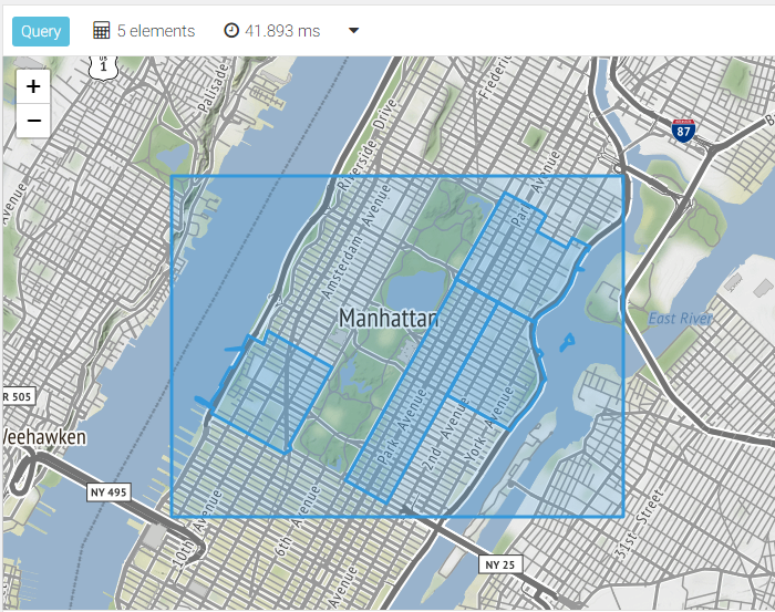
Searching for geo features in a rectangle is something you can use together with an interactive map that the user can select the area of interest with. Take a look at the lunch break video about the ArangoBnB demo project to learn more.
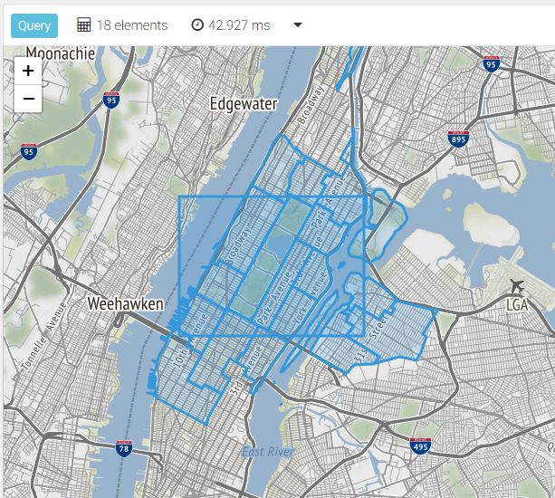
Search for polygons intersecting polygons
Define a GeoJSON polygon that is a rectangle, then search for neighborhoods that intersect with this area:
LET sides = {
  left: -74,
  top: 40.8,
  right: -73.93,
  bottom: 40.76
}

LET rect = GEO_POLYGON([
  [sides.left, sides.bottom],
  [sides.left, sides.top],
  [sides.right, sides.top],
  [sides.right, sides.bottom],
  [sides.left, sides.bottom]
])

FOR result IN PUSH(
  FOR doc IN restaurantsView
    SEARCH ANALYZER(GEO_INTERSECTS(rect, doc.geometry), "geojson")
    RETURN doc.geometry,
  rect
)
  RETURN result